Bantjes, Rod, “Document name.html,” in Eigg Mountain Settlement History, last modified, 29 March 2024 http://people.stfx.ca/rbantjes/gis/txt/Introduction.html.
Lot 321 Mrs. Dan MacPherson (Eigg Mountain Settlement History)
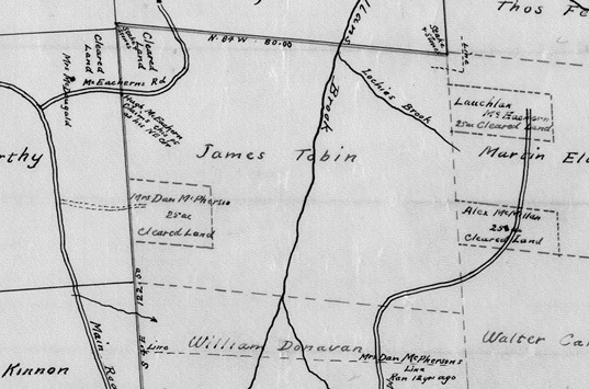
This lot appears on Plan B-11-1 of “Escheated Lands,” 1912. The implication is that all these lands were being reconveyed to the Crown. The surveyor, Albert McKean, indicates this and other sites as simply “25 ac. cleared land.” He places it on land granted to James Tobin and apparently does not recognize that Mrs. MacPherson had title. Despite claiming that the plan was “from actual survey” these cleared plots are evidently penciled in without measurements being taken. I am using boundaries guessed at from the aerial photos (A8462-47) and an incomplete ground survey.
However, in 1900 McKean notes that Mrs. MacPherson “ran a line” to the north indicating that she probably considered herself to be owner of a full 200+ acre lot, assuming that she also ran a line west from the southern edge of her fields (see Figure 1).
Figure 1 – Plan B-11-1 detail. (south is at the top)