Bantjes, Rod, “Document name.html,” in Eigg Mountain Settlement History, last modified, 29 March 2024 http://people.stfx.ca/rbantjes/gis/txt/Introduction.html.
Grants Book M, p.64, 1828 (Eigg Mountain Settlement History):
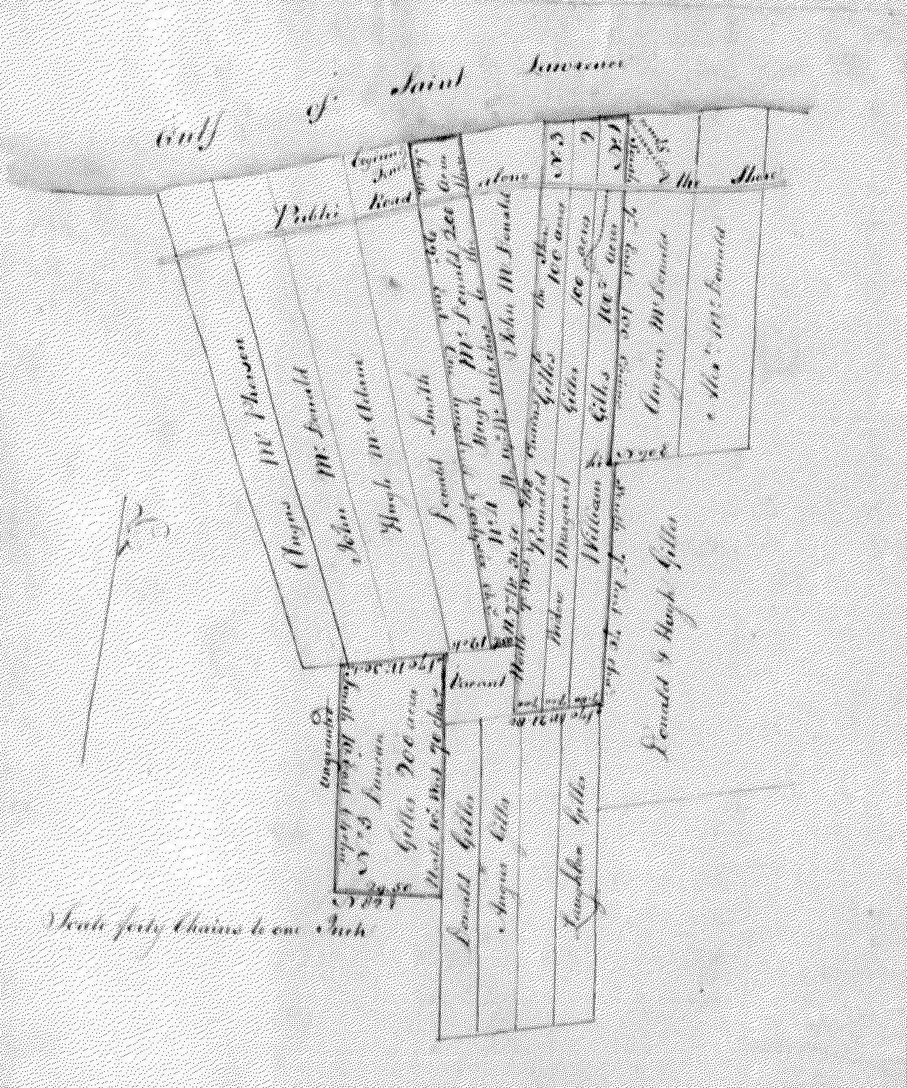
Grantees: William Gillis, Margaret Gillis widow, Randall Gillis, Hugh McDonald and Duncan Gillis all of Gulf shore Antigonish in the County of Sydney.
700 acres of land in the same situated lying and being in said county in the following tracts and lots to wit:
1. Unto said William Gillis that certain tract marked number one on the annexed plan.
2. unto the said [widow] Margaret Gillis that certain tract marked number two.
3. unto the said Ranald Gillis [Roderick Gillis on Grant Index 93] that certain tract marked number three in said annexed plan containing in each of said tracts numbers 1, 2 and 3, 100 acres
...and are abutted and bounded as follows: that is to say
…beginning at a spruce tree standing on the North Western angle of land granted Angus MacDonald fronting on said Gulf shore
…thence south 7° East along the western side line of said McDonald's land crossing the main public road leading along the shore 100 chains to the end thereof
…thence north 70° East to the northeastern angle of Donald and Hugh Gillis land
…thence south 7° East along the western side line of said land 70 chains to the northeastern angle of Laughlan Gillis land thence south 70° West along the lower line of said land 21 chains eighty links
…thence north 7° West on vacant land in the eastern side line of John Donald land 168 chains Crossing said road to the shore
…thence easterly along the same to the place of beginning.
…Reserving to the said William Gillis the use of the road about 12 feet wide crossing into the said Margret Gillis land to avoid a steep hill
4. ...unto the said Hugh McDonald that certain tract marked number four on annexed plan containing 200 acres and is abutted and bounded as follows that is to say
…beginning on the eastern angle of land granted Donald Smith fronting on said Gulf shore at the line fence
…hence south 20° East along the eastern side line of said land 146 chains
…thence south 70° East on vacant land seven chains 50 links to the western side of line of said lot number three
…thence north 7° West along said side line 31 chains 50 links to the upper angle of said John MacDonald land
…thence north 19° West along the western side line of said land crossing said road 116 chains to the shore
…thence westerly by the same to the place of beginning.
5. Unto said Duncan Gillis that contains tract marked number five on the annexed plan containing 200 acres and is abutted and bounded as follows, that is to say
…beginning at the rear line of the first division of farm lots fronting on said Gulf
…thence at a distance of 12 chains from the south western angle of said lot number four
…thence south 70 degrees West along said rear line 30 chains and south 10° East on ungranted land 64 chains
…thence north 82° East 29 chains 50 links to the western side line of Donald Gillis land
…thence north 10° West along said side line and vacant land 70 chains to the place beginning.
Plan: