Town Common
This area is marked on the 1787 Town Point Map as ‘the Land Set Aside for a Common, Gift of T. R. Hierlihy.’ It appears to extend to the water on three sides. This was likely meant to be common grazing land, but may never have been put to this use. It is across the harbour from the townsite and adjacent to only one individual grant. People were probably meant to move by water between the townsite where they lived, the commons and their fields on individual grants.
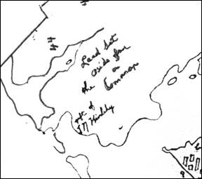
Detail from the 1787 Town Point Map. It is left in its original orientation so north is towards the bottom left. Town Point is in the bottom right.