Bantjes, Rod, “Maps.html,” in Eigg Mountain Settlement History, last modified, 14 August 2015 (http://people.stfx.ca/rbantjes/gis/txt/eigg/introduction.html).
Maps (Eigg Mountain Settlement History)
Church Map (1878)
Geological Survey Map (1886)
Grants Map (1953)
Fernow’s (1912)
Soil Survey Map (1953)
Church Map (1878)
Ambrose Finson Church produced a series of maps of Nova Scotia counties financed by subscription. The series appears to have been copyrighted or “entered according to law on the twenty-fourth day of March, 1864.” The Nova Scotia Department of Natural Resources (http://novascotia.ca/natr/library/oldmaps2.asp) cites research by Charles Bruce Fergusson indicating that the Antigonish map was actually produced in 1878.[1] So it is this date I have used for the data.
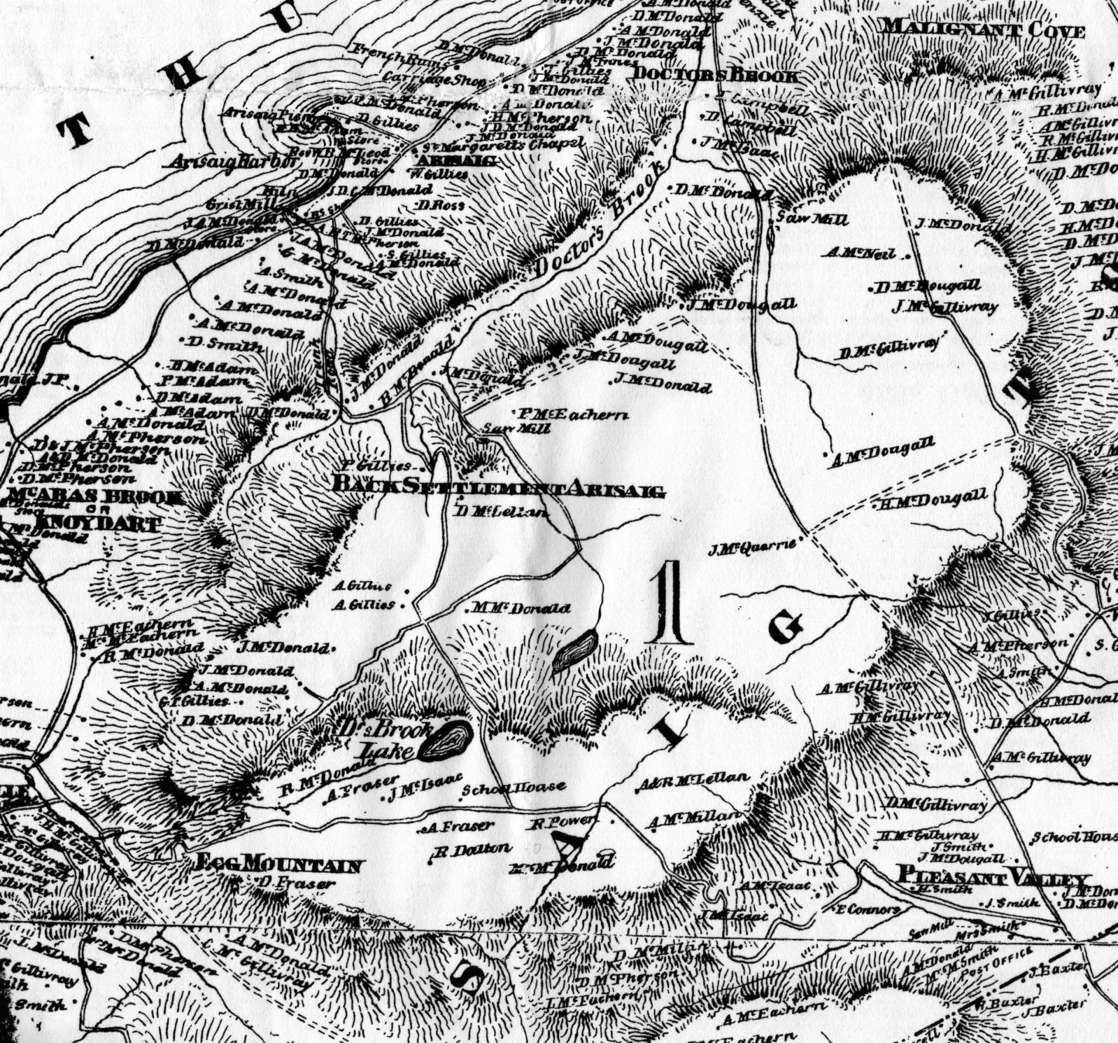
Figure 1 – Detail of the A. F. Church Map showing Eigg Mountain.
Unlike the Geological Survey Map, the geography of the Church Map is so distorted that it is impossible to georeference to the modern base map in ArcView. I love the old mapping conventions such as using hatching where modern maps would use contour lines to indicate slopes (for a particularly beautiful example of this see the Bayfield map of Antigonish Harbour). I also like the accelerating wave lines used to indicate a coast line and have incorporated it on my own map.
Geological Survey Map (1886)
This was the second most useful map for the project. It indicates many buildings and names of residents. It was “Compiled and drawn by J. A. Roberts, from plans made by the Admiralty and Department of Crown Lands, Nova Scotia and the Geological Survey” It is Part P, Volume II of Fletcher, Hugh, and Eugene Rodolphe Faribault. Report on Geological Surveys and Explorations in the Counties of Guysborough, Antigonish, Pictou, Colchester, and Halifax, Nova Scotia, from 1882 to 1886. Montreal: Dawson brothers, 1887.
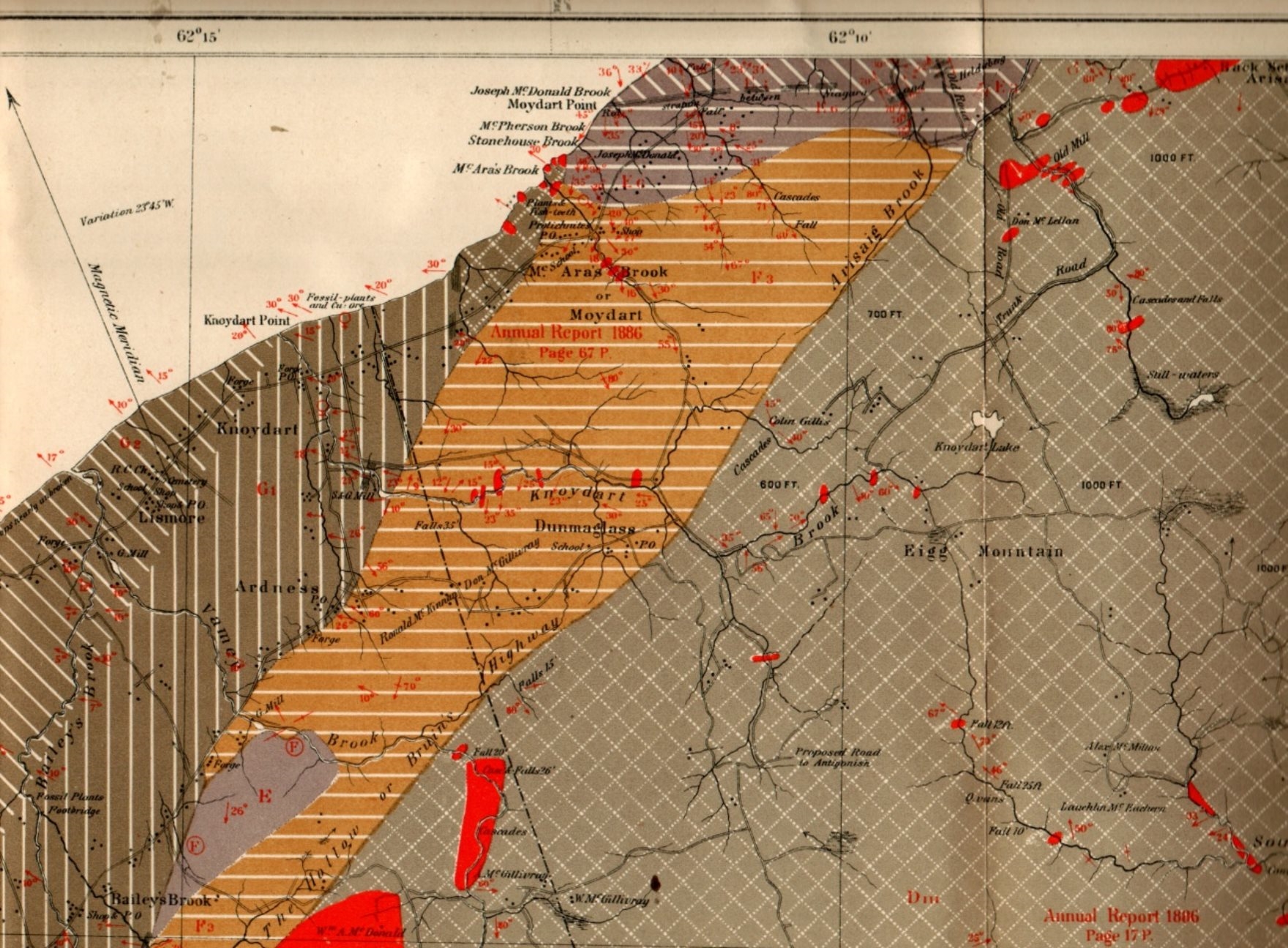
Figure 2 – Geological Survey Map detail showing Eigg Mountain.
The Geological Survey map makers draw the user’s attention to the difference between true north and magnetic north. The variation in 1886, known as declination in modern terms, was considerable: 23º 45’. Note that the boundary line between Pictou and Antigonish counties more-or-less follows magnetic north – indicative, I think, of a general Nova Scotia tendency at the time to treat magnetic as though it were true north. I do not have an image of the key to this map, but clearly the grey with a square grid of white dotted lines indicates the resistant bedrock geology that forms the substrate of the Antigonish highlands.
Grants Map (1953)
A series of maps were produced by the Department of Lands and Forests providing a geographic index to Nova Scotia land grant records. For more on how the index works see Land Grants: Eigg Mountain Area. The map for the Eigg Mountain area (Index Sheet no. 98) was compiled in 1948 and revised in 1953. I have used it, in conjunction with current property boundaries and land grant plans, to produce the property boundaries on the ArcView map. I have also used it as a source for road locations.
To see a copy of the map go to: http://novascotia.ca/natr/land/indexmaps/098.pdf). See also a detail of the map georeferenced to the ArcView base map.
Fernow’s (1912)
Bernhard Eduard Fernow, former chief of the United States Department of Agriculture’s forest division helped to compile a map of the state Nova Scotia’s forests in 1912 for the Canadian Commission of Conservation. B. E. Fernow, C. D. Howe, and J. H. White, Forest Conditions of Nova Scotia (Ottawa: Commission of Conservation, 1912). The map is also map digitized and available from http://novascotia.ca/natr/forestry/gis/fernow.asp.
See a detail of Fernow’s map georeferenced to the ArcView base map.
Soil Survey Map (1953)
For an image of the Soil Survey map and a discussion of its relevance to Eigg Mountain, see Eigg Mountain Soil Fertility.