Bantjes, Rod, “Finding_Places.html,” in Eigg Mountain Settlement History, last modified, 14 August 2015 (http://people.stfx.ca/rbantjes/gis/txt/eigg/introduction.html).
Finding Places (Eigg Mountain Settlement History)
Charlie Teasdale and I had been hunting all day for the tiny, indistinct imprints of old foundations, as hidden in the dense woods as pennies dropped in the ocean. We had been amazingly successful earlier, but now we had been circling around for close to an hour like hounds that had lost the scent. We’d had to squeeze through heavy thickets and thread around marshy ground. It was buggy and we had had enough. So we were doing a last sweep on our way out when I had a feeling that said “wait, don’t go yet.” I stopped, and realized that I hadn’t checked one of the GPS waypoints for this area that I had prepared earlier. It was from a blurry white spot on a grainy digitized aerial photo from 1945 that looked to Charlie and me like it might indicate a collapsed building in a clearing.
The GPS pointed back and to the right. I followed the countdown “350 m, 347m, 346m…” as the GPS approached its target. Before it was done I could tell the ground felt right: it was drier. The trees thinned out to a clearing and there, maybe fifty metres away was a level spot: “the barn” I thought. Sure enough, on close inspection there was enough stone to indicate the minimal, rough foundation that settlers gave their barns. I shouted “Charlie! Found it!” I turned to look up a slope and thought – knew even though I didn’t see it, “there’s the house.” I have had these experiences more than once in the woods – the first is like being called, the second is simply knowing where I will find a house foundation.
This was the Allan MacDonald house on Brown’s Mountain. Its situation was typical: a high, dry spot never on the top of a rise, but always just below, out of the wind, on a little knoll. The little prominence on which the house sits is sometimes natural, but more often partly built up using the material dug from the cellar. In the woods if you sight below the bottom branches and dip your head up and down for motion parallax, the hidden foundation will show itself as a slightly elevated line with a hint of a drop into the cellar behind it. Kenton Teasdale tells how the old people used to locate house sites by watching how the cattle chose sheltered spots to bed down for the night. Finding these sites nearly 200 years later sometimes involves learning to think like a highland settler, or maybe like their cattle, “where would I put the house?”
Often, well before the house is within sighting distance, both Charlie and I get a feeling that it is close by. I think what we are sensing are the distant repercussions of the intense cultivation of the choice fields close to the house. The soil composition would have been changed by manuring and its surface altered by the removal of rock and repeated working over by plough or caschrom.[1] Maybe a unique mix of vegetation takes over here, something more subtle than the white spruce monoculture.[11] Often these places remain grassy and clear of trees as though the ghosts of the old people returned in the moonlight to scythe the field and arrest the natural succession. Examples include the Allan MacDonald House on Brown’s Mountain, one of the J. MacDonald sites on the Gault Road, Brown’s Mountain, the environs of Big Archie MacDonald’s house, Eigg Mountain, and a site on the back settlement Eigg Mountain.
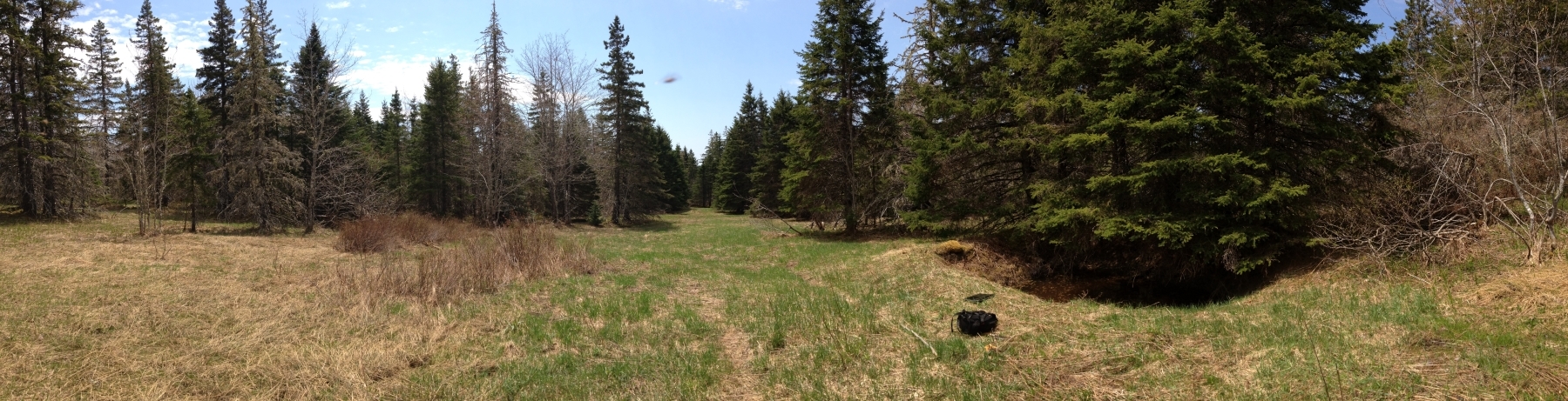 |
Figure 1 – Panorama of one of the J. MacDonald sites on the Gault Road, Brown’s Mountain. |
| The centre is looking south towards the barn. The house is on the right under the spruce tree. This is a clearing deep in the bush that apparently has not been logged since the field was abandoned at least 70 years ago. |
It is very rare in long-abandoned sites in the highlands to find the remnants of cultivated plants. Apples in the forest are always signs in the lowlands that you are close to an old house site. These sites were usually abandoned later than those in the highlands. We have found apple trees on Brown’s Mountain, but in the highlands generally old orchards have been long overgrown and strangled of sunlight – a process that takes perhaps 60 years. It is possible to find rhubarb and ornamentals surviving in the open at lowland sites. The only highland survivals that settlers might have planted are gooseberries.[2] It is the volunteer plants that colonize abandoned fields that leave the clearest mark. A succession of grasses and opportunistic broad-leaf plants followed by shrubs such as alder and willow, then small conifers which gradually outgrow their neighbours, cut off their light and acidify the soil, and culminates eventually in the domination of the softwoods, typically white spruce, over mossy floors.
An even-aged stand of white spruce over a level floor[3] is a good sign that you are on a former field, although not that you are near a house. You could be on pasture some distance from the farmyard. There are a number of ways to rule out fields, none of them decisive. Marshy ground is one. However wet ground under forest canopy might have been dry when cleared. Steep banks and uneven surfaces are another. Pit and mound topography, or what local people call “cradle hills,” results from an ancient blow-down of a mature forest. As massive root systems are pulled from the ground they drag earth up with them creating the pits. As the roots decay they slowly drop their load of earth in a mound to one side of the pit. Such ground is too uneven for crops of even hay fields since harvesting, even with a scythe, would be difficult. There is no absolute reason why pit and mound could not have been used for pasture, but in practice it seems never to have been.
Mixed or pure stands of hardwood are another good way of ruling out former fields; although as an indicator it is occasionally uncertain and subject to debate. Charlie and I have found two examples of what appear to be cellars in hardwood stands. One example is about 200 metres down a steepening slope from what we are sure were the former fields of Dan MacPherson.[4] The hardwood cover suggests that this site was not part of the field and no other evidence, such as rock piles, indicates that it was. Farm houses should always be within fields, or when they are at the edge of a field that is almost always in order to be close to a main road. It only makes sense not to have to walk far from the house in order to take up the daily work on the land. This location, while far from the main road, is on a secondary road, impossible now to discern on the forest floor. Still, being off the field does not seem right.
You can see if you read our account that we started to question whether what we had found was actually a house foundation. Any evidence of a built wall is usually decisive. But these walls have all collapsed. As is often the case, the stone is partially hidden with infill. However at least here there is stone, stone that was selected for the properties that make it good for building walls. Sometimes basements were dug but not lined with rock walls.[5] Charlie thinks these unlined basements were for shanties that setters built simply from logs before they had the means to erect more permanent structures. The houses built on stone foundations had post and beam frames made of timbers squared with broadaxe and adze and an envelope of sawn boards and clapboard. The only surviving example from Eigg Mountain is Lame Angus MacEachern’s.
An unlined basement over time becomes merely a shallow rectangular depression in the ground. Occasionally we have had some doubt about whether these depressions were actually once dug basements. A raised berm, the actual support of the walls, is another good indicator. These raised foundation lines should, even when there is no basement, have some rock to support the walls and keep the wood from rotting by coming onto contact with the soil. Sometimes, even when cellar walls are evident, foundation lines can be fragmentary. The surviving rock is almost always below the surface and can only be located by tapping with a steel instrument. To be sure that an unlined depression is a basement Charlie also looks for a “ramp” down one side which is evidence that a bulldozer may have dug it out for some other reason. We rule out the bulldozer hypothesis at this questionable site in the hardwoods.
What we have before us is probably an old farmhouse in a young hardwood stand. So here’s where the debate lies. Charlie has always insisted that hardwood stands were never fields. I agree that fields always grow up first in softwood and most fields abandoned in the twentieth century would still support the characteristic early softwoods. But there is evidence that people were already beginning to leave highland sites as early as the 1870s, and in isolated cases, for whatever reason, maybe earlier.[6] Over that time scale, 130 years, it’s conceivable that a further succession to hardwood – the sugar maple, yellow birch and stunted beech now common on the Mountain – may have had time to begin. White spruce can live to 200 years or more,[7] but on the Mountain we find lots of deadfall of trees in the 60 to 80 year range.[8] The openings they leave might provide the opportunity for hardwoods to take hold. A young stand might be able to grow up from former fields within the 130 year cycle.
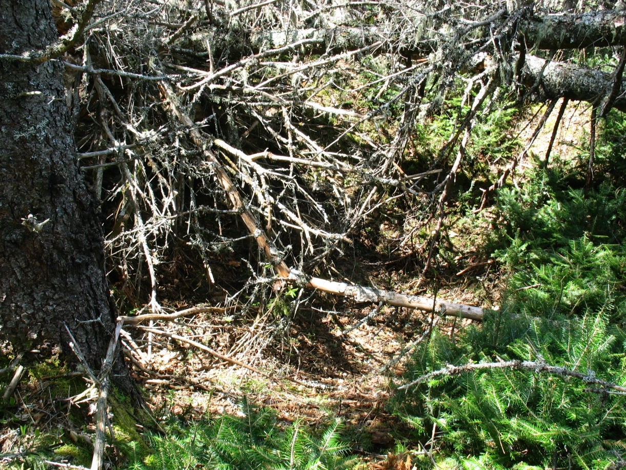 |
Figure 2 – Cellar of the H. (Mason) MacDougall House. |
| This foundation was obscured by deadfall and impossible to see until I nearly stepped into it. |
All of this logical reasoning and debate, fun in and of itself, is one of the ways in which I over time formed the intuitions that, without me having explicitly to think about it, guide me through the forest, or rather allow me to navigate that historical layer of the bygone landscape. What most intrigues me is that feeling of tuning into this past, like picking up a faint staticy signal of an old radio broadcast. It’s what I mean by feeling “called.” If I attend carefully and follow the signal, it gets stronger; if I take a wrong turn I lose it. This is how it was when we were looking for the H. (Mason) MacDougall site near the McQuarrie Stillwater in Highfield. Charlie and I had been criss-crossing an area to the west of the Stillwater that was open beneath the canopy and had lots of evidence of rock walls and stone piles (but no house). Then I tuned into something coming from a gently rising ridge leading north. Here the forest was choked with deadfall and moving through it was like climbing through a jungle gym. The rising ground was dry and it felt, with no GPS point to guide me this time, like I was following a homing beacon. The strange thing was that while I ended up going straight to the cellar, it was impossible to see under the piles of deadwood until I almost stepped into it (see Figure 2).
I know Charlie often has the same kind of feeling. While I attribute it to an intuitive ability to sense the past landscape and to appreciate its logic in the way that the early settlers did, Charlie thinks of it as sensing the presence of people. In other words he thinks that the spirits of the old people are sometimes at our sides when we trespass on their forgotten world. If I entertain this thought, I have to ask the question, which I think Charlie also asks: “why would they want us to find them?” Charlie’s brother Kenton talks about how suspicious Highland Scots were of the census-takers. Why would the British Crown want to know where they were located, what they owned and how many children they had if not to tax them or conscript their young men for imperial wars? Knowledge can be a means of gaining power over others, and it is not always wise to let yourself be known.
If the old people were guiding Charlie and me and showing us their work in building the old landscape, what would their purpose be? I really can’t answer that question, but just asking it has given me a sense of responsibility to the people whose lives and struggles I have been gathering evidence of. Charlie, I think, believes that they want their work not to be forgotten or erased. He sees this mapping project as the best method for preserving the ways in which their struggles have left traces in the landscape. I am trained as a sociologist, so getting the facts right is important, but I cannot help asking how we should make sense of or explain the facts. There has been some debate about the Catholic highland settlers of Nova Scotia and some criticism of their skills as farmers, even from their own people.[9] No-one has written specifically about the people from Ireland and the Scottish highlands who settled in the Antigonish highlands. In my analysis in these pages I have tried to use what little I know to reconstruct their side of the story, since they have no-one else to speak for them.[10]